I have walked by these towers so many times without even noticing them. Your eye just seems to ignore the interruption of the beauty of the landscape. Today I finally did notice and took a shot. The camera captured it perfectly.
Tags: wires electricity power lines towers California blight ugly black & white b&w Explored 320
© All Rights Reserved
LARGE view.
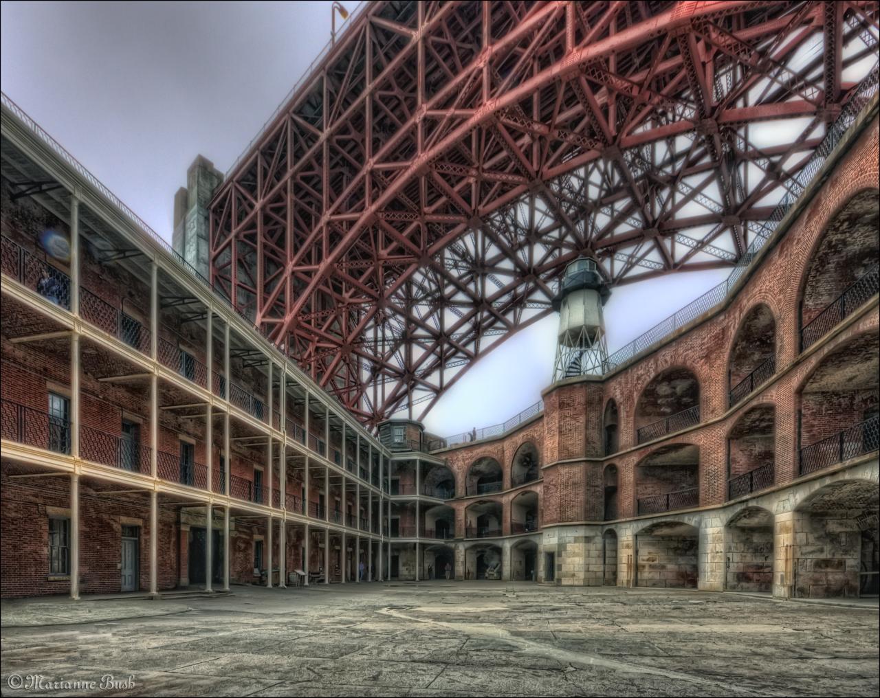
Fort Point has stood guard at the narrows of the Golden Gate for nearly 150 years. It has been called “the pride of the Pacific,” “the Gibraltar of the West Coast,” and “one of the most perfect models of masonry in America.” When construction began during the height of the California Gold Rush, Fort Point was planned as the most formidable deterrence America could offer to a naval attack on California. Although its guns never fired a shot in anger, the “Fort at Fort Point” as it was originally named has witnessed Civil War, obsolescence, earthquake, bridge construction, reuse for World War II, and preservation as a National Historic Site.
Fort Point was built between 1853 and 1861 by the U.S. Army Engineers as part of a defense system of forts planned for the protection of San Francisco Bay. Designed at the height of the Gold Rush, the fort and its companion fortifications would protect the Bay’s important commercial and military installations against foreign attack. The fort was built in the Army’s traditional “Third System” style of military architecture (a standard adopted in the 1820s), and would be the only fortification of this impressive design constructed west of the Mississippi River. This fact bears testimony to the importance the military gave San Francisco and the gold fields during the 1850s.
Unfortunately, I'm still dealing with a very painful neck problem so cannot sit in the same position for very long. I'll visit in increments.
Tags: Ft. Point Golden Gate Bridge San Francisco fort brigde GGB HDR Photomatix SFChronicle 96Hrs. Interestingness Explore #488
© All Rights Reserved
The Mary D. Hume, built at this spot in 1881, had the longest active service of any commercial vessel on the Pacific coast, a total of 97 yrs as freighter, whaling vessel, to towboat service. She, broke after being docked here, and the wreck remains
By the way, all those tiny dots in the background are gulls. There were hundreds of them.
Tags: wreck ship boat Gold Beach beached river Oregon The Mary D. Hume 1881 Interestingness Explore ImpressedBeauty Rogue River #58
© All Rights Reserved
View LARGE
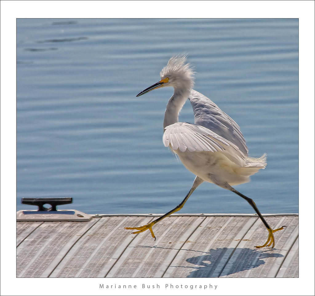
Tags: Egret Egretta Thula snowy Egret strut white bird shorebird the intimidator NaturesFinest SpecAnimal ImpressedBeauty AvianExcellence Explore Interestingness #255 #11 BRAVO
© All Rights Reserved
©2008 Marianne Bush
Better Large
Front Page Explore
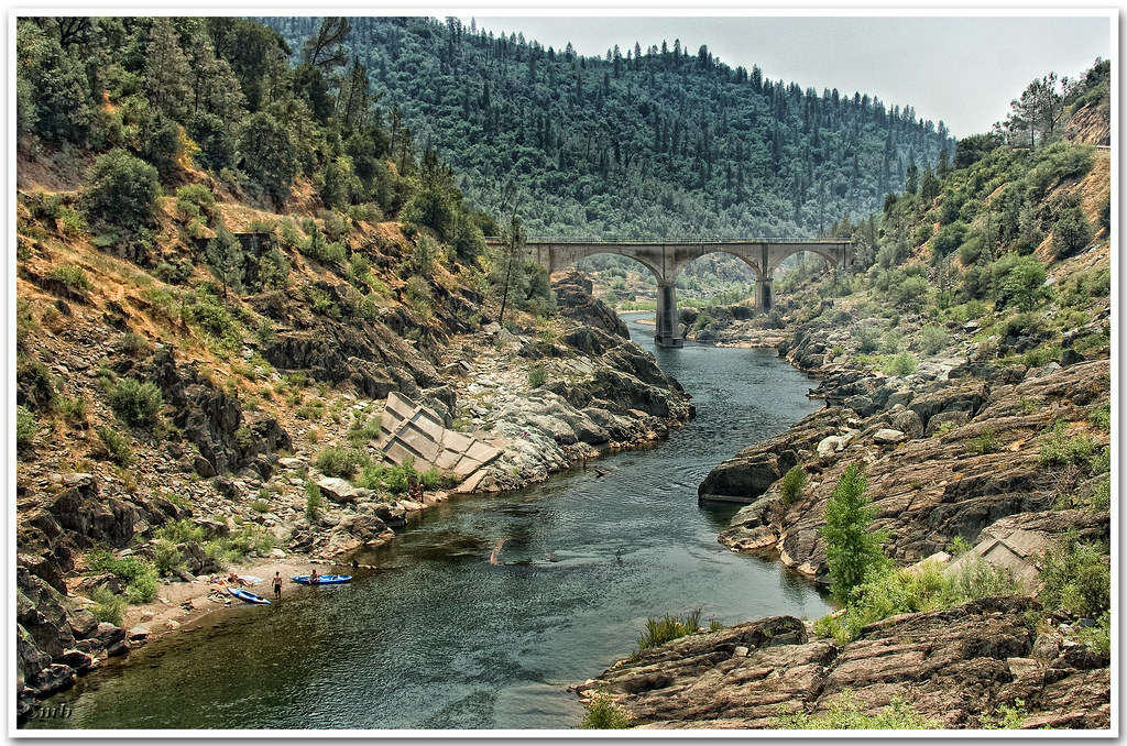
Just found the reason for those slabs on either side of the river:
The Mountain Quarry Cement Bridge, later known as "No Hands Bridge," was completed on March 23, 1912, by 600 men working on the Placer County side and 200 more on the E1 Dorado side to the tune of $300,000. At the time of its construction the bridge was the longest concrete arch bridge in the world. The building of this structure proved that concrete was practical for building long bridges. Although it was plagued by various problems during construction , the span was considered a great piece of railroad bridge engineering.
The old cement bridge stands today as a proud monument to early-day engineering and the men who built it. The bridge has withstood the tugging of the American River currents for over 80 years and stayed on its footings when the Hell Hole Dam broke in December 1964 and took out two modern bridges upstream. It also withstood the so-called "Valentines Day Flood" of 1986, which submerged the bridge before destroying a 250-foot earth-filled coffer dam two miles down river.
The cement bridge has served as a landmark since the railroad went out of service in the 1940s. It did, however, serve a purpose shortly after the Hell Hole dam flood. The dam, located some 40 miles upstream, brought millions of tons of thundering water down the Middle Fork. The force of the water tore out the newer concrete-and-steel highway bridge nearby that linked Auburn with Cool and Georgetown. But the cement railroad bridge survived and was quickly pressed into temporary service to restore vehicle traffic between the two counties.
The rail route's 15 trestles and lines of tracks were removed in the 1940s: the metal and other materials were used in the war effort.
Today, a portion of the old rail route is designated as the Western States Pioneer Express Recreation Trail, in accordance with the National Trails System Act. It is primarily used by horsemen, runners and hikers. The name "no hands" came from veteran rider, Ina Robinson, who would drop her reins to ride across the then guardrail-less bridge. The bridge now stands as the "gateway to Auburn" and the final American River crossing of the Western States 100 Mile Endurance Run.
Tags: American River No Hands Bridge river Placer County California bridge Gold Country SFChronicle 96Hrs. Explore Interestingness #16
© All Rights Reserved