June 8, 2019 - West Central, South Central Nebraska
Prints Available...
Click Here
All Images are also available for...
stock photography & non exclusive licensing...
Watch the Storm Chasing Video from that day's Chase on Flickr
Click Here
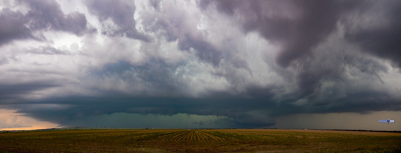
No tornadoes on this day's chase, but some incredible supercell structure out on the plains of Nebraska.
We started the day with a supercell that had several meso structures being reported from radar. This storm was tracking slowly about 12 knots cresting from the northwest to southeast. Classic June storm structure for this time of year in Nebraska. Northwest of North Platte Nebraska it had reported wall cloud and we definitely wanted a piece of this action.
We arrived as it was gaining strength as it has pushed through Maxwell Nebraska. We stopped in Brady, just to the southeast via I-80 corridor to get the bugs off of the windshield and as the storm was gaining strength. We had stopped just a few miles to the south of Brady we set up shop to catch this storm. Nice clear beautiful structure accompanied the underbelly of this supercell. Though we had a clear cut defined wall cloud this storm never did show us her tornadic teeth.
After about an hour on this storm in the same position (rare for us to do this) we eventually had to back off and get back to the east. We had to get south of Gothenburg just a few miles off the I-80 exit area for the next structured shot of this supercell. Oh we got just what we were looking for! Phenomenal base rotation!
Eventually we had backed off again as the hail core was approaching. Plus this cell was loosing its steam. We moved back to the I-80 corridor then south of Cozad Nebraska and this cell was in redevelopment mode and we had some waiting to do. Though not a long wait as this original cell fizzled out but we had one more chance for good structure south of Overten Nebraska. We headed to Loomis Nebraska for another treat to end the day. Oh did I say treat? We got a whole bunch more eye candy than expected.
Just to the east of Loomis Nebraska we encountered some incredible supercell structure. This storm wasn't going to be shy, and she eventually showed us some teeth.
Personal Note: For some odd reason I didn't clear my memory card on my last chase, and I ran out of room on my SD Card. I had to stop shooting after the wall cloud was right over my location my Loomis Nebraska. I didn't have time to pull out my spare card and load it due to the strength and this fast moving cell. This storm cell became outflow dominate and man do I mean dominate. We got caught in the outflow boundary several times with tons of gustnadoes and almost haboobish. I did have my trusty camera with me... I was in the drivers seat so when we had a chance, I did capture some incredible pics that blew me away literally. Either I'll make another short video to proceed this one or you'll have to wait till I get them posted on my Flickr site flickr.com/nebraskasc.
All in all. I'm not always about catching the tornado. I had some good friends and fellow storm chasers along side that day. In my opinion... just another EPIC chase day in Nebraska!!! Woot Woot. More to come!
*** Please NOTE and RESPECT the Copyright ***
Copyright 2019
Dale Kaminski @ NebraskaSC Photography
All Rights Reserved
This image may not be copied, reproduced, published or distributed in any medium without the expressed written permission of the copyright holder.
#ForeverChasing
#NebraskaSC